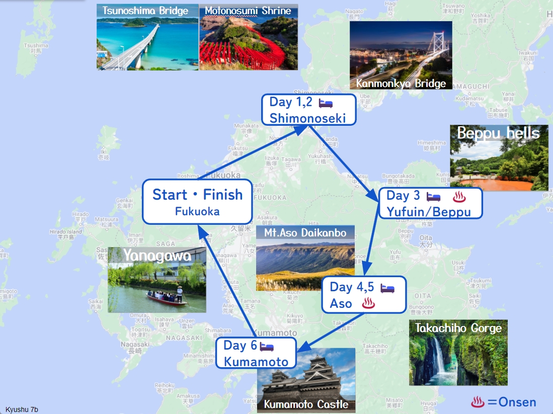
Summary
- Start
Fukuoka Airport or Hakata Station - Finish
Fukuoka Airport or Hakata Station - Mileage
Total 990km
140km per day - Travel Pace
Relaxing - Onsen Stay
Max.3 nights - Recommended Seasons
All year round
This itinerary takes 7 days to circle the northern Kyushu and Yamaguchi area of the main island.
By staying consecutive nights in 2 cities and standard daily mileage, you can travel at a relaxing pace.
Fukuoka-Shimonoseki(Sample)
Start : Fukuoka (福岡)
Finish : Shimonoseki (下関)
Mileage:130km
Travel Pace: Normal
On this day, you will head from Fukuoka to Shimonoseki.
Please understand that across the Kanmon Straits, Shimonoseki(下関) is on the north side and Moji(門司港) is on the south side.
1
Rental car branch at Fukuoka airport or Hakata Station
Parking MAPCODE:
9:00
The driving distance planned for this day is 130km, which is a relatively relaxing drive. However, if your departure time is late, such as leaving in the afternoon, adjust your schedule by taking the expressway or skipping some spots.
30min
2
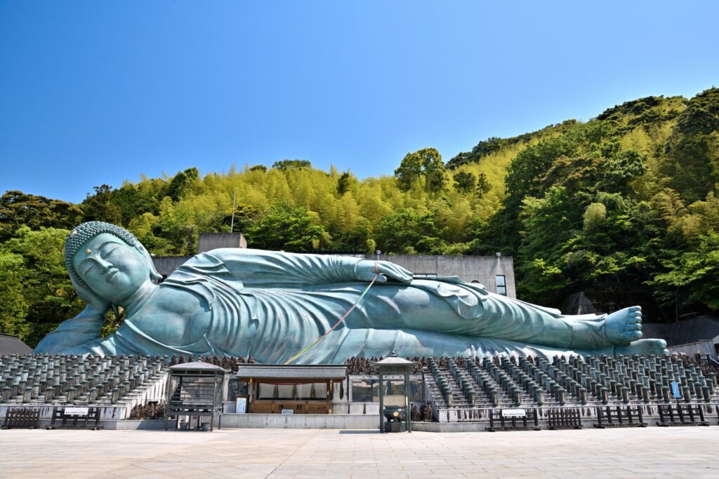
Nanzoin Big Buddha-南蔵院
Parking MAPCODE:
55 699 644What is MAPCODE?
9:30
The first destination is Nanzoin Temple, home to the huge reclining Buddha statue, which is 41m long, 11m high, and weighs 300 tons, making it one of the largest bronze statues in the world.
40min
3
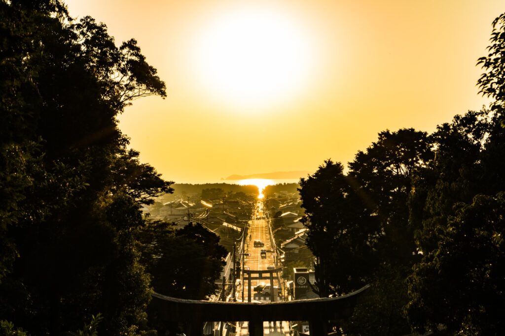
Miyajidake Shrine-宮地嶽神社
Parking MAPCODE:
375 088 700What is MAPCODE?
11:30
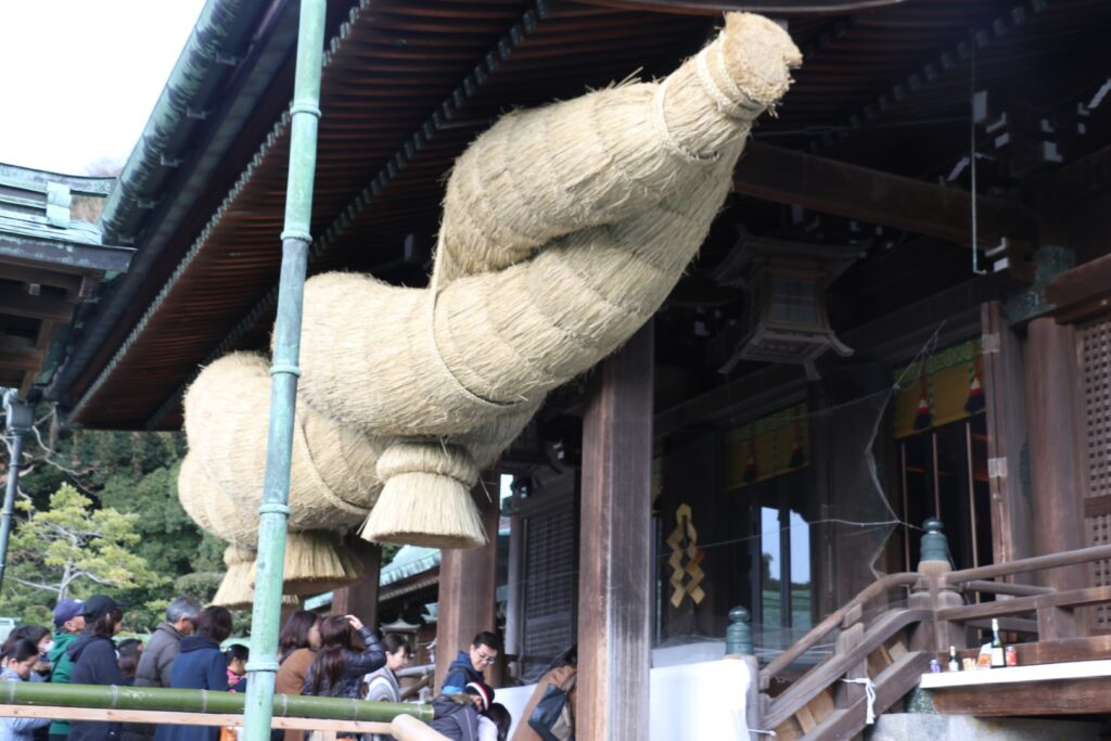
Next, you will visit Miyajidake Shrine, which has a beautiful view all the way to the sea.
Also, here are the three largest ones in Japan, so be sure to enjoy them as well.
1) A large Shimenawa(a sacred Shinto rope of rice straw) with a diameter of 2.6 meters, a length of 11 meters, and a weight of 3 tons.
2) Large drum with a diameter of 2.2 meters
3) A large copper bell weighing 450 kg
70min
4
Mojiko Port Retro Area-門司港レトロ
Parking MAPCODE:
16 715 449What is MAPCODE?
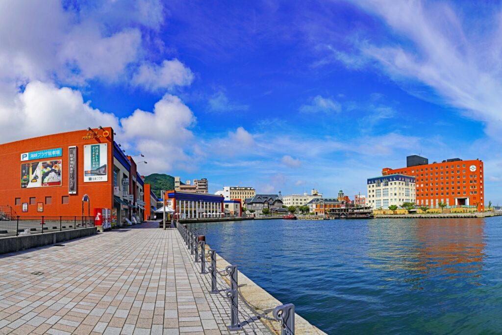
13:30
The next stop, Mojiko Retro, is a long way away, so please use the expressway (E3). This area is lined with old Western-style buildings, including the former Mitsui Club, where Einstein stayed, and you can enjoy the beautiful scenery. For lunch, Mojiko’s famous grilled curry(Yaki curry-焼きカレー) is recommended.
10min
5
Kanmonkyo Bridge(Mekari Daini Observatory)-関門橋(和布刈第二展望台)
Parking MAPCODE:
16 746 490What is MAPCODE?
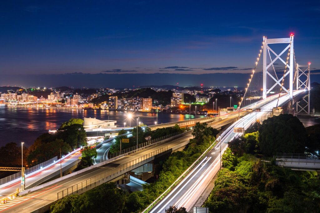
15:30
The highlight of the day is Mojiko Port and Shimonoseki, located across the Kanmon Strait. Please head to [Mekari Daini Observatory] on the Mojiko Port side. Unknown to most travelers, this observation deck, accessible only by car, is the best spot to view the Kanmon Bridge and the Kanmon Straits!
25min
6
Inn in Shimonoseki
Parking MAPCODE:
Please head to the hotel you reserved.What is MAPCODE?
If you have time after checking in to the hotel, one option is to go to Mt. Sarakurayama Observatory. You can enjoy a wonderful night view overlooking Kitakyushu. However, please note that it is a little far away and takes 30 minutes from Mojiko by expressway.

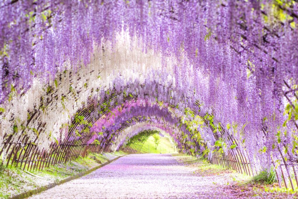
If you’re traveling in spring or fall, you might want to stop by Kawachi Fuji Garden. This place is famous for its wisteria (mid-April to early May) and autumn leaves (mid-November to early December).
Also, if you are traveling with children, we recommend Uminonakamichi Seaside Park. There are many facilities that children will enjoy.
The driving map will show an additional 10-20 spots for the day! You will travel only to your favorite spots.
Check pin color and MAPCODE usage.

On this day, you will stay in either Shimonoseki city or Mojiko. Shimonoseki is on the north side across the Kanmon Straits and Mojiko is on the south side. It is 10km and takes about 20min.
- Inn Type
Most of these inns are 3 to 4-star western-style hotels. - Parking
Some inns have official parking but in addition to the accommodation fee, the parking lot fee will be charged separately. - Onsen
Most of the inns in the two towns don’t have onsens. - Meal Plan Reservations
There are some restaurants around the hotel for dinner. If you plan to have breakfast at the market the next morning, it is good idea to book with no meals.
Shimonoseki – Shimonoseki🔒
Start : Shimonoseki (下関)
Finish : Shimonoseki (下関)
Mileage:190km
Travel Pace: Fast
This day is the day between two consecutive nights in Shimonoseki.
On this day, you will depart from Shimonoseki, visit the main tourist spots in Yamaguchi Prefecture, and return to Shimonoseki.
1
Inn in Shimonoseki
Parking MAPCODE:
9:00
The distance covered on this day is 190km, which is a bit of a long drive, so please use the expressway as much as possible.
60min
2
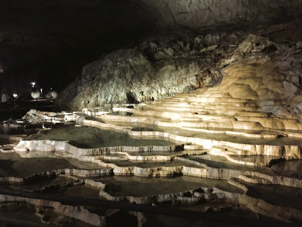
Akiyoshido Limestone Cave- 秋芳洞
Parking MAPCODE:
🔒Book rental car or hotelWhat is MAPCODE?
10:00
The first destination of the day is ”Akiyoshido Limestone Cave”. There aren’t many sightseeing spots up to this point, so please use the expressway (E2A).
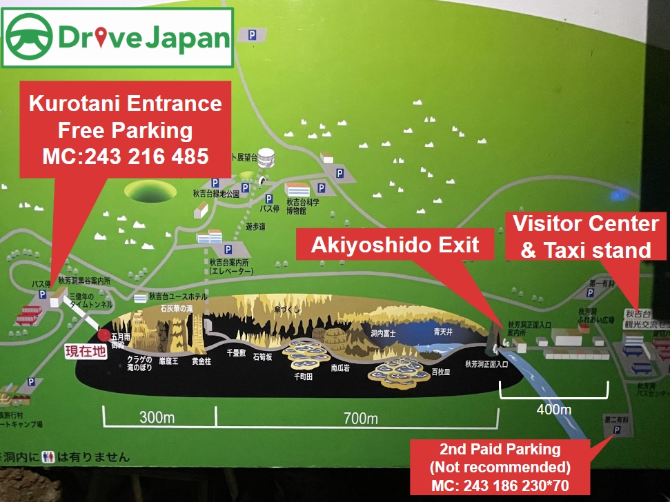
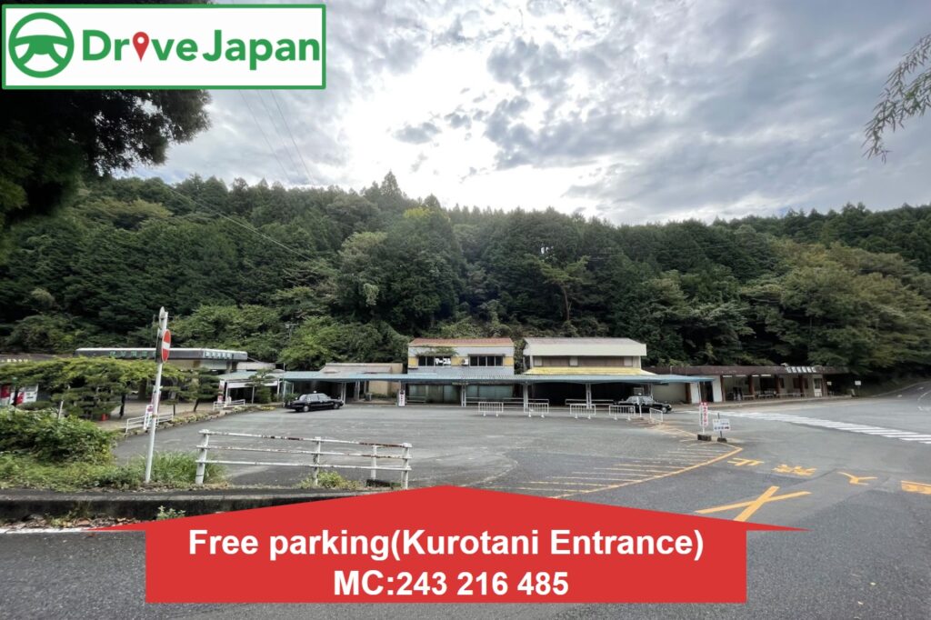
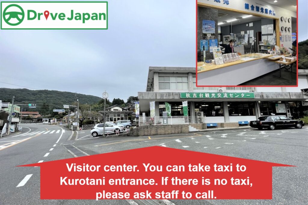
At Akiyoshido, you have several walking options, but we recommend entering from the Kurotani Entrance and walking to the Akiyoshido Exit. There is a visitor center about 300 meters further from Akiyoshido Exit, so we recommend taking a taxi from the taxi stand next to it to return to the parking lot near Kurotani Entrance. Of course, if you want to go around the cave, you can walk back to the Kurotani Entrance.
10min
3
Chojagamori parking lot – 長者ヶ森駐車場
Parking MAPCODE:
🔒Book rental car or hotelWhat is MAPCODE?
11:40
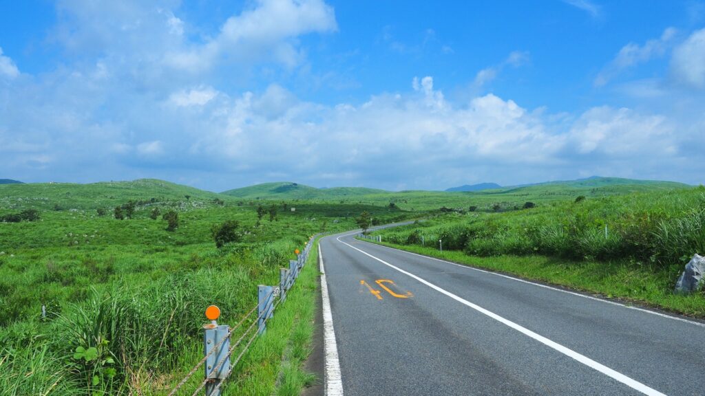
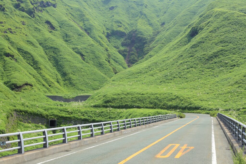
Next, you will head to Chojagamori parking lot. This area is known as the Akiyoshidai Karst Plateau. Drive slowly and enjoy the scenery. We especially recommend the approximately 3km road from Akiyoshido to Chojagamori parking lot.
40min
4
Roadside Station Senza Kitchen -道の駅センザキッチン
Parking MAPCODE:
🔒Book rental car or hotelWhat is MAPCODE?

12:40
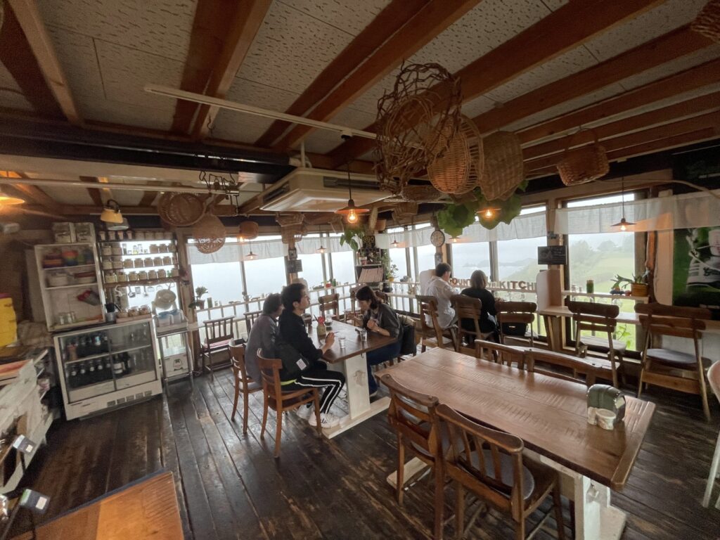
Next, you will head to “Roadside Station Senza Kitchen” located at the entrance of Omi Island. This is a large roadside station, and the Omi Island sightseeing boat departs from here. If you don’t have time, you can enjoy lunch here, but if you have time, we recommend lunch at the next Senjojiki Country Kitchen.
30min
5
Senjojiki Country Kitchen-千畳敷カントリーキッチン
Parking MAPCODE:
🔒Book rental car or hotelWhat is MAPCODE?
13:40
Next, enjoy lunch at ”Senjojiki Country Kitchen”. If the weather is nice, we recommend having lunch on the terrace while looking out at the Sea of Japan.
10min
6
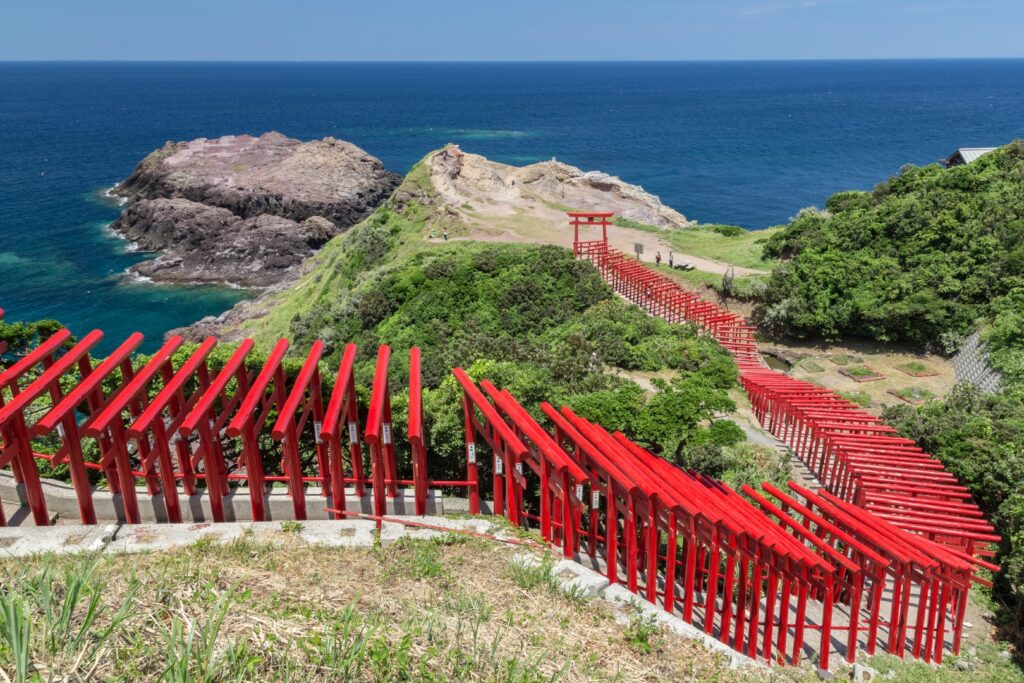
Motonosumi Inari Shrine-元乃隅稲成神社
Parking MAPCODE:
🔒Book rental car or hotelWhat is MAPCODE?
14:30
After enjoying lunch, head to ”Motonosumi Inari Shrine”, where many vermilion torii gates line up facing the sea. It is a popular spot that looks great on SNS.
40min
7
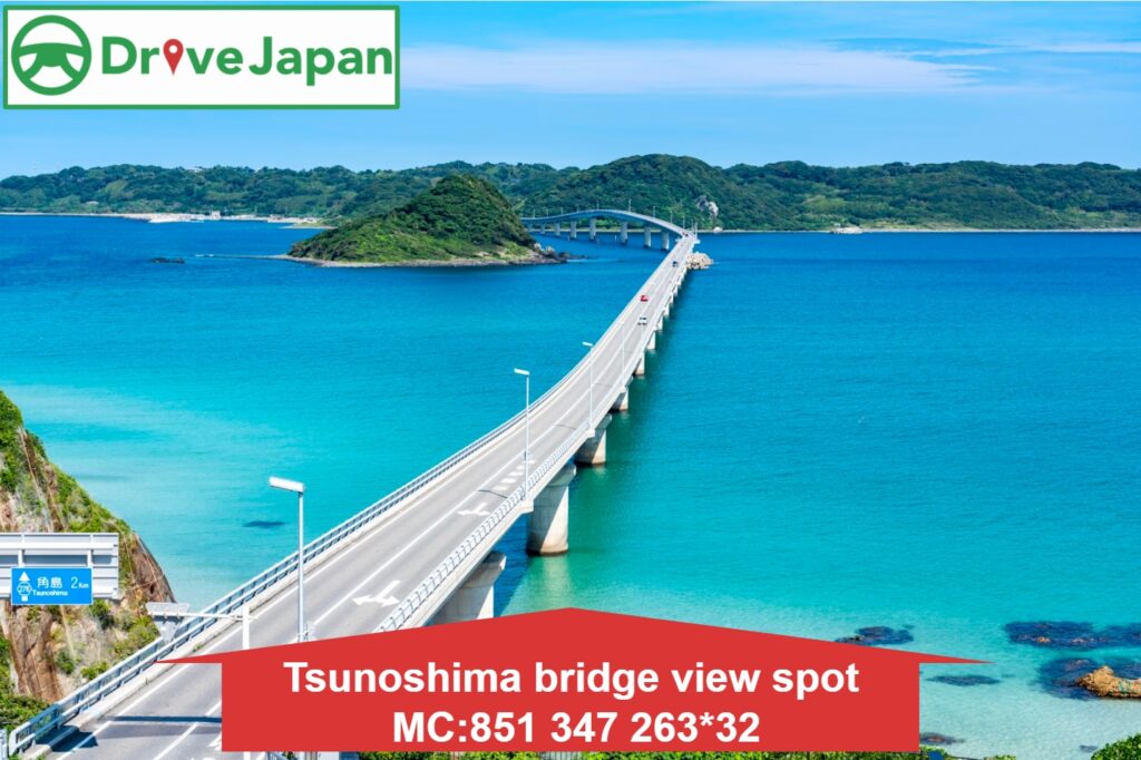
Tsunoshima Ohashi Bridge-角島大橋
Parking MAPCODE:
🔒Book rental car or hotelWhat is MAPCODE?
16:00
The next destination is “Tsunoshima Ohashi Bridge“, which has also become famous on social media. This bridge, with its white sandy beach and cobalt blue ocean in the background, is a must-see as often seen in TV commercials.
30min
8
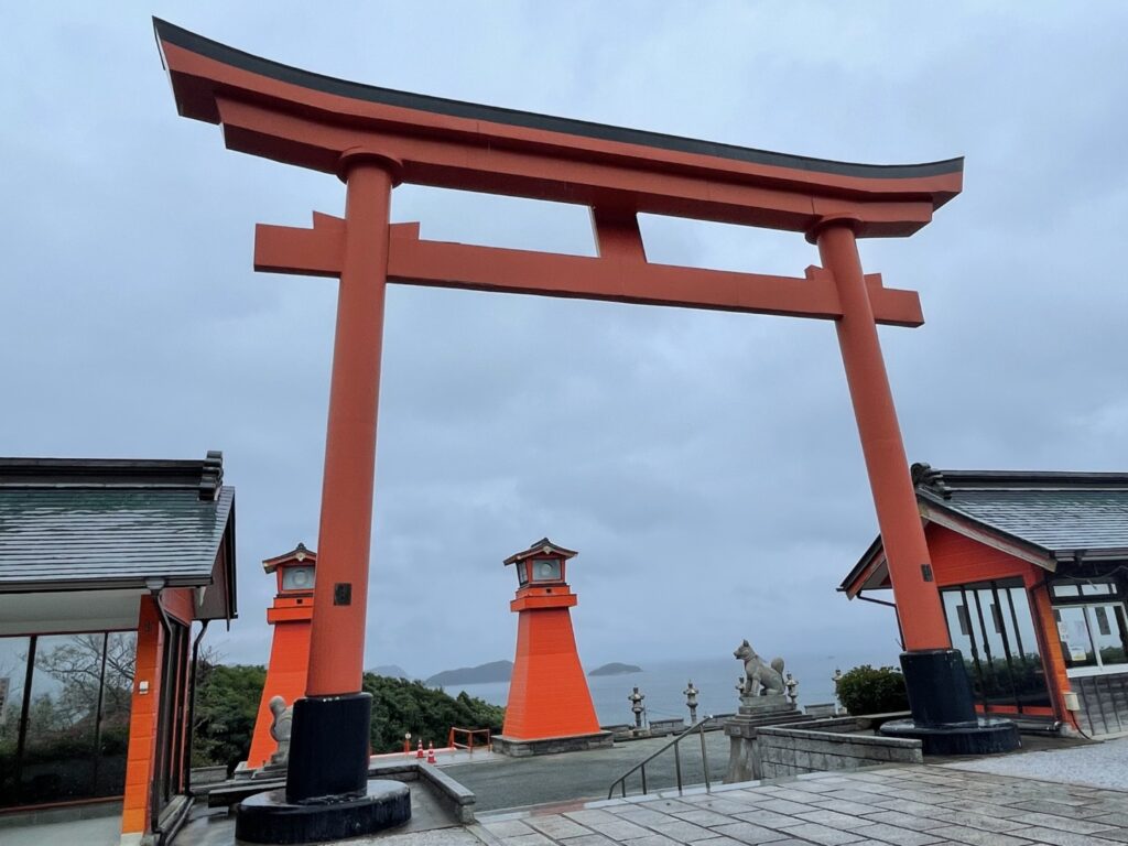
Fukutoku Inari Shrine-福徳稲荷神社
Parking MAPCODE:
🔒Book rental car or hotelWhat is MAPCODE?
17:00
The last stop of the day is “Fukutoku Inari Shrine“. A shrine known for its vermilion large torii gate and 1,000 torii gates. From the hill, you can see the sea and surrounding islands.
(This shrine has strict rules for taking photos, so please be careful not to take photos from the front of the shrine or with your back to the shrine.)
45min
9
Inn in Shimonoseki
Parking MAPCODE:
Please head to the hotel you reserved.What is MAPCODE?
If you have time after checking in to the hotel, one option is to go to Mt. Sarakurayama Observatory. You can enjoy a wonderful night view overlooking Kitakyushu. However, please note that it is a little far away and takes 30min from Shimonoseki by expressway.
The driving map will show an additional 10-20 spots for the day! You will travel only to your favorite spots.
Check pin color and MAPCODE usage.
On this day, you will stay in either Shimonoseki city or Mojiko. Shimonoseki is on the north side across the Kanmon Straits and Mojiko is on the south side. It is 10km and takes about 20min.
- Inn Type
Most of these inns are 3 to 4-star western-style hotels. - Parking
Some inns have official parking but in addition to the accommodation fee, the parking lot fee will be charged separately. - Onsen
Most of the inns in the two towns don’t have onsens. - Meal Plan Reservations
There are some restaurants around the hotel for dinner. If you plan to have breakfast at the market the next morning, it is good idea to book with no meals.
Shimonoseki – Yufuin/Beppu🔒
Start : Shimonoseki (下関)
Finish : Yufuin(湯布院) or Beppu(別府)
Mileage:180km
Travel Pace: Fast
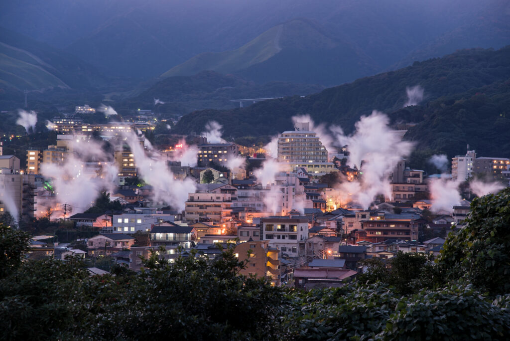
On this day, you will head from Shimonoseki to the famous Onsen resort town of Yufuin or Beppu.
Because of the long driving distances and because the stores in Yufuin and Beppu Hell close at 5:00 p.m., try to take the expressway as much as possible.
1
Inn in Shimonoseki
Parking MAPCODE:
8:00
You can have breakfast at the hotel, but we recommend having it at Karato Market. Some restaurants in the market open from 6 am.
10min
2
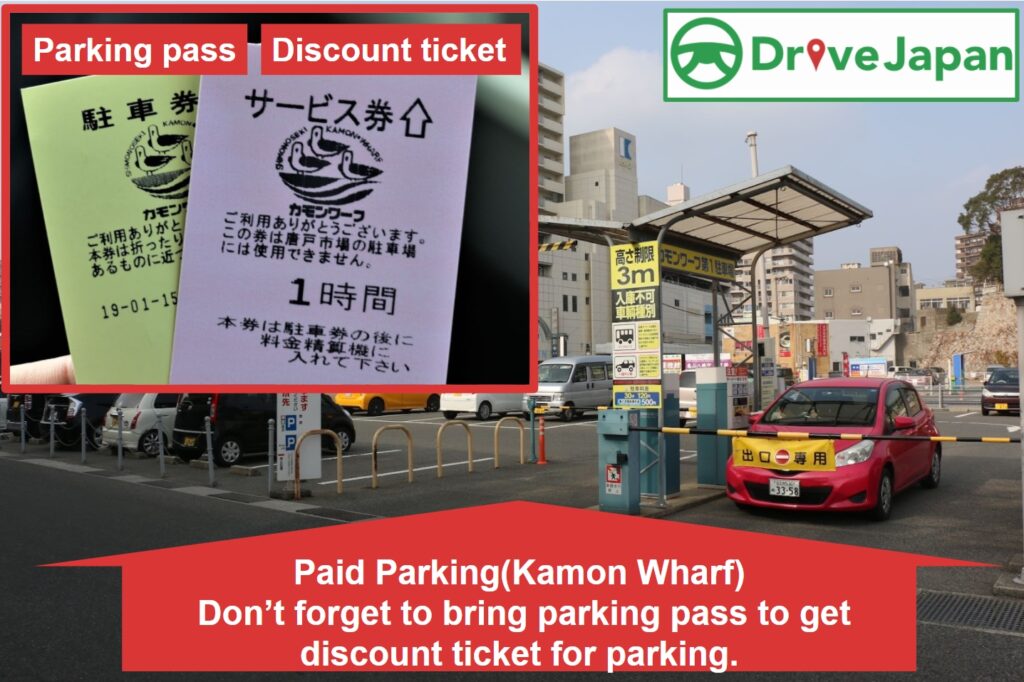
Karato Market&Kamon Wharf-唐戸市場&カモンワーフ
Parking MAPCODE:
🔒Book rental car or hotelWhat is MAPCODE?
8:10
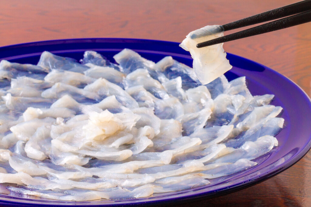
The first destination for the day is “Karato Market & Kamon Wharf”. Kamon Wharf, located next to the fish market named Karato Market, serves delicious dishes made with fresh fish. Especially recommended is the famous “Fugu (Pufferfish)” from Shimonoseki.
50min
3
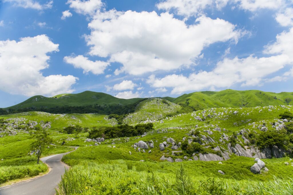
Hiraodai-平尾台
Parking MAPCODE:
🔒Book rental car or hotelWhat is MAPCODE?
9:40
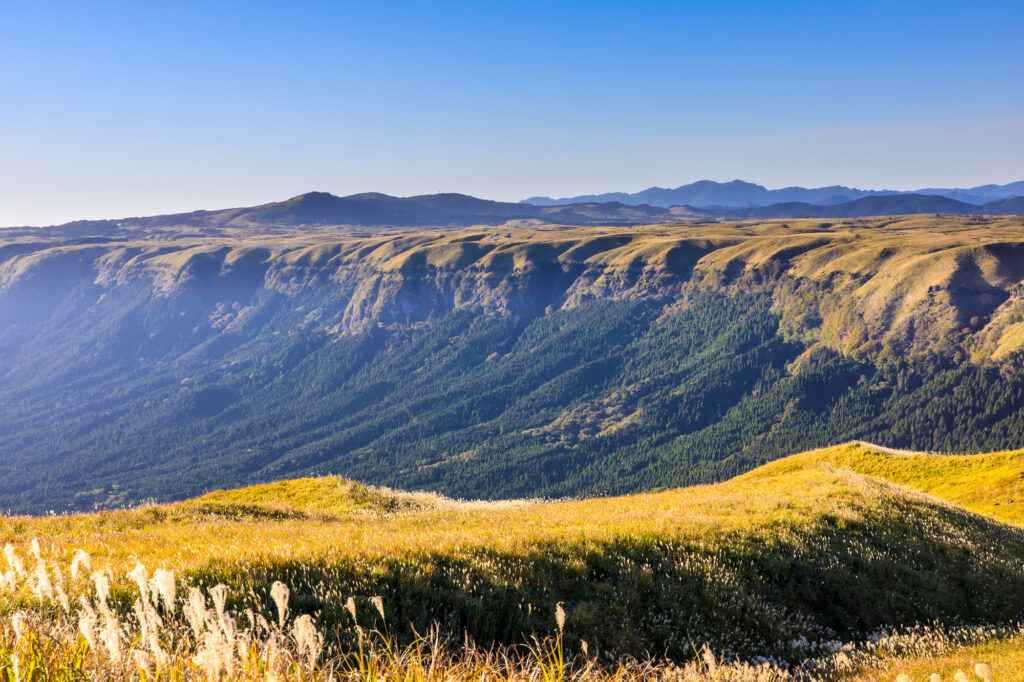
Next, you will head to Hiraodai, which is one of Japan’s most representative karst plateaus, with many scattered pieces of pure white limestone reminiscent of a flock of sheep playing in a grassy field, and has been designated as a natural monument along with underground limestone caves.
However, most of the stores in Yufuin and Beppu Hell close at 5:00 p.m., so if you are in a hurry, you can consider skipping Hiraodai.
50min
4
Chicken House Nakatsu main store (lunch)-チキンハウス 中津本店
Parking MAPCODE:
🔒Book rental car or hotelWhat is MAPCODE?
11:00
Next, you will head to Chicken House Nakatsu main store for early lunch which is one of the most well-known Karaage restaurant in Nakatsu city.
Nakatsu is the most famous town in Japan for its “Karaage (Japanese style fried chicken)”, and there is an episode about KFC, which twice expanded into the area but had to pull out due to lack of sales growth.
You can check MAPCODE for recommended local Karaage shops on the day-by-day Driving Map.

60min
If you’re planning to stay in Beppu tonight, follow this itinerary and head to Yufuin after lunch. If you are planning to stay in Yufuin tonight, please head to Beppu first after lunch and then to Yufuin. This is required in order to visit all recommended sites by 17:00 on the same day.
If you stay in Yufuin or Beppu for 2 nights, it is OK to travel at a more relaxed pace.
5
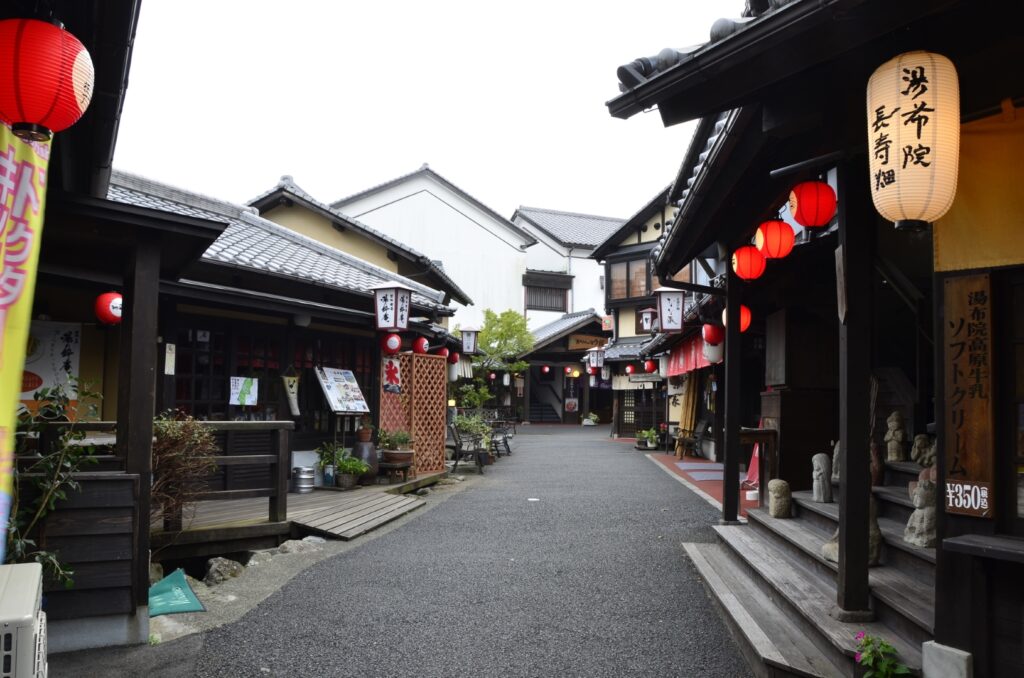
Yufuin Yunotsubo Street-湯布院湯の坪街道
Parking MAPCODE:
🔒Book rental car or hotelWhat is MAPCODE?
12:45
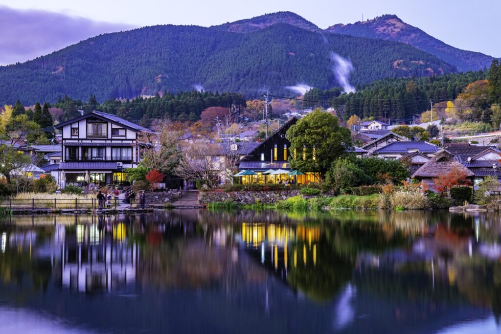
Once you arrive in Yufuin, we recommend strolling along the Yufuin Yunotsubo Kaido (Yufuin Yunotsubo Avenue), lined with souvenir stores and cute little sweet stores. Enjoy eating and walking to Kinrin-ko Lake at the road’s eastern end.
Another highlight of the day, the “Beppu Jigoku Hells”, will close at 17:00. If you wish to visit it, leave Yufuin by 2:30 p.m. at the latest.
30min
It is a 25-km, 30-minute drive from Yufuin to Beppu. The drive through the foot of Mt. Yufudake is exhilarating.
6
Beppu Jigoku Hells-べっぷ地獄めぐり
Parking MAPCODE:
🔒Book rental car or hotelWhat is MAPCODE?
14:30
“Beppu Jigoku Hells” symbolizes onsen town Beppu, where hot water of various colors boils over! The seven hells are divided into two main areas as follows, about 3 km or 10 minutes by car. Five of the seven hells are within walking distance.
Each area can be explored on foot.
Be aware that all Jigoku closes at 17:00.

Kannawa District(5 Jigokus)
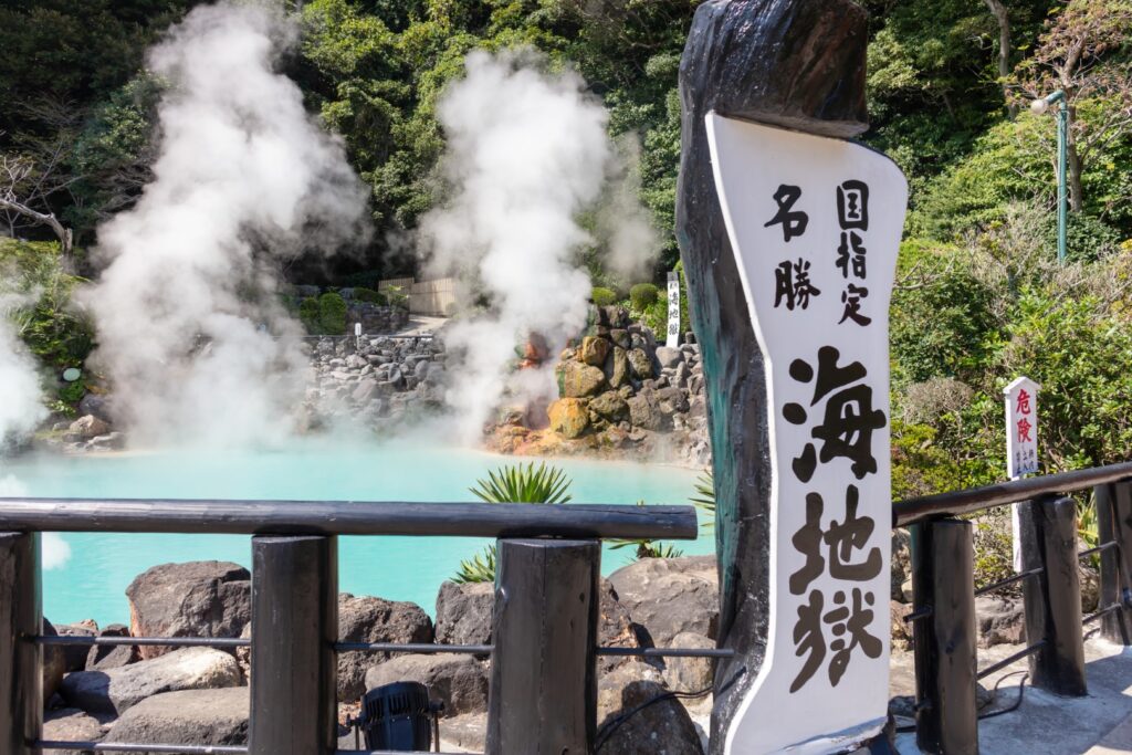
There is big free parking at Umi Jigoku. You can park there and visit 5 Jigoku on foot.
●Umi Jigoku-海地獄
Time required: 30 min
●Oniishibozu Jigoku‐鬼石坊主地獄
Time required:15 min
●Kamado Jigoku‐かまど地獄
Time required: 20 min
10min walking from Umi Jigoku or MC: 46 522 481.
●Oniyama Jigoku-鬼山地獄
Time required: 10 min
●Shiraike Jigoku‐白池地獄
Time required: 10 min
Shibaseki District(2 Jigokus)
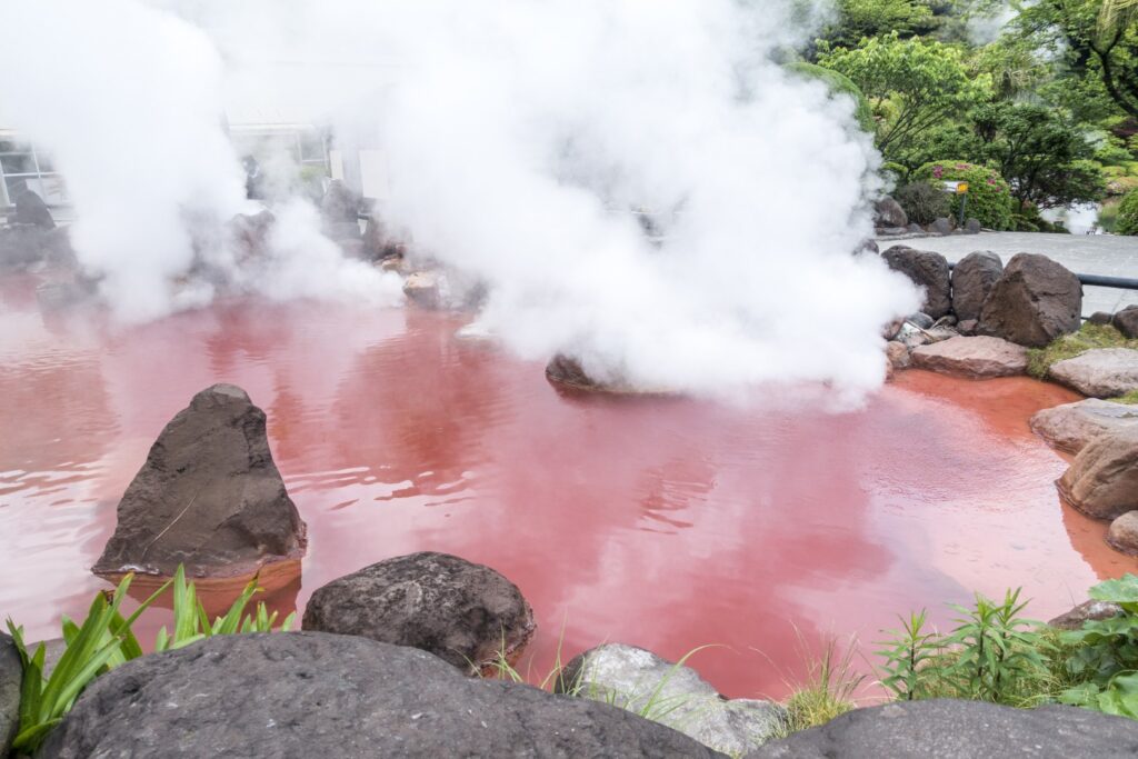
You can park at Chinoike Jigoku. Tatsumaki Jigoku is located right next door and you can visit on foot.
●Chinoike Jigoku-血の池地獄
Time required: 15 min
●Tatsumaki Jigoku-龍巻地獄
Time required: It is a geyser that erupts once every 30 to 40 minutes. This means that you will have to wait up to 40 minutes.
Beppu Jigoku Hells Official
15min
6
Inn in Yufuin or Beppu
If you are traveling during cherry blossom season, we recommend going to Oita River Cherry Blossom. The Yufuin Nature Promenade along the Oita River is decorated with cherry blossoms and rape blossoms, with Mt. Yufu in the background. Usually, the best time to see cherry blossoms is around early April.

If you are traveling with kids, Harmony Land is the place for you. It is a Sanrio character park with attractions such as Hello Kitty and My Melody.
The driving map will show an additional 10-20 spots for the day! You will travel only to your favorite spots.
Check pin color and MAPCODE usage.
On this day, you will stay in either Yufuin town or Beppu city. It is 20km long and takes about 30 minutes. Both of them are nationally famous Onsen areas.
①Yufuin(湯布院)
Yufuin is small but has many luxury Onsen Ryokans.
- Inn Type
Most of these inns are 4 to 5-star Japanese-style Ryokans with Onsen facilities. - Parking
Most inns will offer free parking. - Onsen
This town is famous for Onsens and most of the inns have one. - Meal Plan Reservations
There are a few restaurants in this area, so be sure to make a reservation with a plan that includes dinner and breakfast.
②Beppu(別府)
Beppu is a Bigger City and has More Inexpensive Inns.
- Inn Type
Most of these inns are 3 to 5-star Japanese-style Ryokans with Onsen facilities. - Parking
Most inns have official parking but in addition to the accommodation fee, the parking lot fee will be charged separately. - Onsen
Beppu is famous for Onsens and most of the inns have one. - Meal Plan Reservations
As many restaurants are open till midnight, it is recommended to book your inns with breakfast only or without meals.
Yufuin/Beppu – Aso🔒
Start:Yufuin(湯布院) or Beppu(別府)
Finish: Aso(阿蘇)
Mileage:140km
Travel Pace: Normal
On this day, you will head from Yufuin/Beppu to Aso.
The driving distance is about 140 km. This is a day where you can enjoy three of Kyushu’s most spectacular driving roads.
1
Inn in Yufuin or Beppu
Parking MAPCODE:
🔒Book rental car or hotelWhat is MAPCODE?
9:00
Because there are so many pots to see, we recommend leaving by 8-9 am if you want to travel without rushing.
If you are staying in Beppu, go to the “Yukemuri Observatory” first, and you will see the typical Beppu scene of steam rising.
60min
2
Kokonoe Suspension Bridge-九重夢大吊橋
Parking MAPCODE:
🔒Book rental car or hotelWhat is MAPCODE?
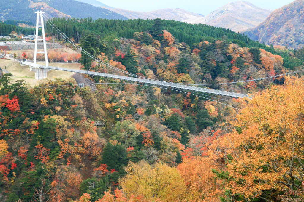
10:20
The first destination is the Kokonoe Suspension Bridge. It is the highest suspension bridge for pedestrians in Japan and is a must-see, especially during the season of fresh green leaves and autumn foliage.
40min
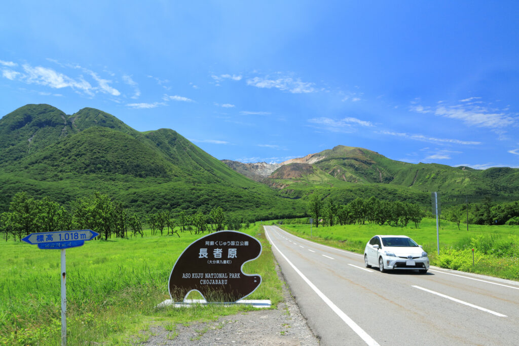
Head south on the Yamanami Highway, the third most popular driving route in Japan. On the way, you can enjoy a fresh yogurt drink at a ranch and a 1km walk in the marshland at Chojabaru. Please refer to the driving map.
Note that Yamanami Highway is a nickname and is actually a public road, not an expressway.
3
Kurokawa Onsen town-黒川温泉
Parking MAPCODE:
🔒Book rental car or hotelWhat is MAPCODE?
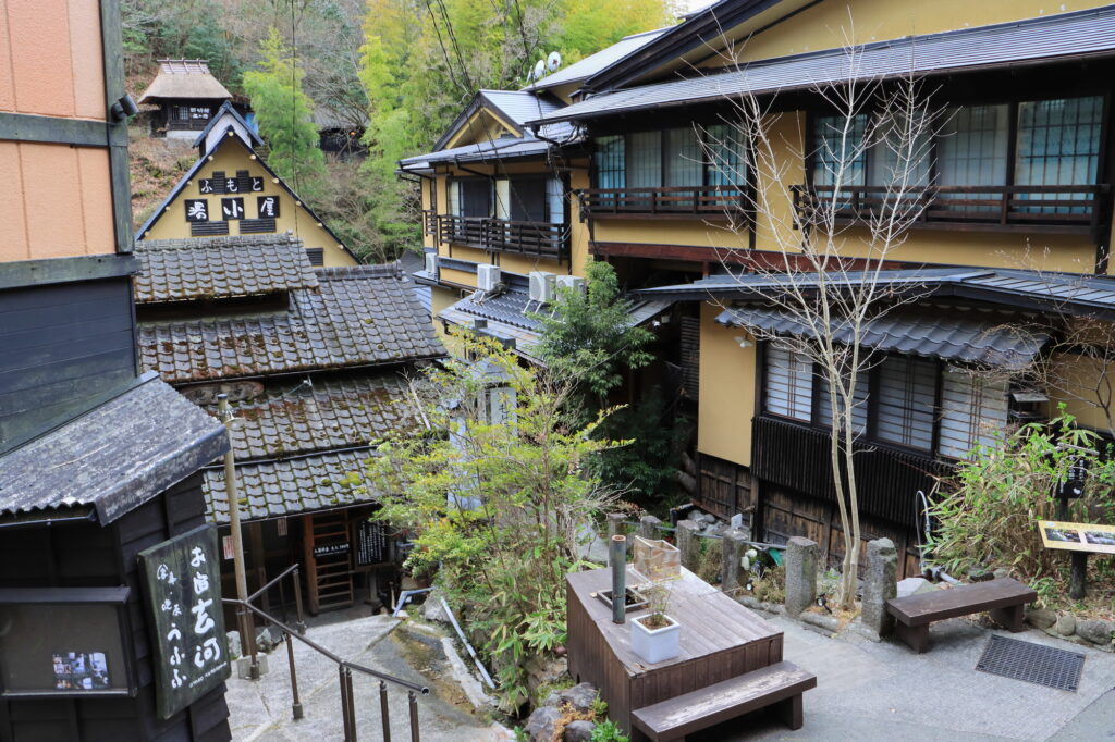
12:00
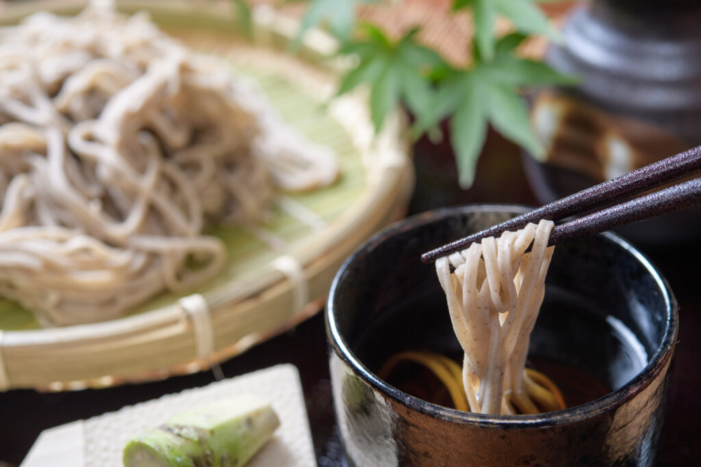
Kurokawa Onsen is a great place for lunch. There are nice curry shops and excellent cream puffs. This spot is also very crowded on holidays. Beyond Kurokawa Onsen, there are a number of soba noodle shops called Oguni Soba Road, which is also recommended. Please refer to the driving map.
35min
4
Nishiyunouraenchi Observatory-西湯浦園地展望所
Parking MAPCODE:
🔒Book rental car or hotelWhat is MAPCODE?
14:15
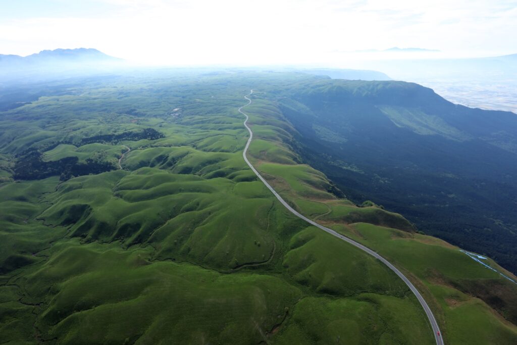
Further south down the Yamanami Highway is the “Nishiyunouraenchi Observatory”. Although not very famous, this is Drive Japan’s best lookout point overlooking the Mt.Aso caldera.
10min
The “Milk Road” from Nishiyunouraenchi Observatory to Daikanbo is the most spectacular road of this road trip, passing by the edge of the caldera of Mt.Aso. The most pleasant drive will make you want to scream, and it will surely be a memory you will cherish forever.
5
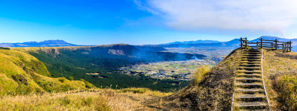
Daikanbo Observatory-大観峰
Parking MAPCODE:
🔒Book rental car or hotelWhat is MAPCODE?
14:45
This is the most famous observatory in the Mt.Aso caldera. Enjoy a 1 km round trip walk on the plateau from the parking lot to the observatory.
30min
6
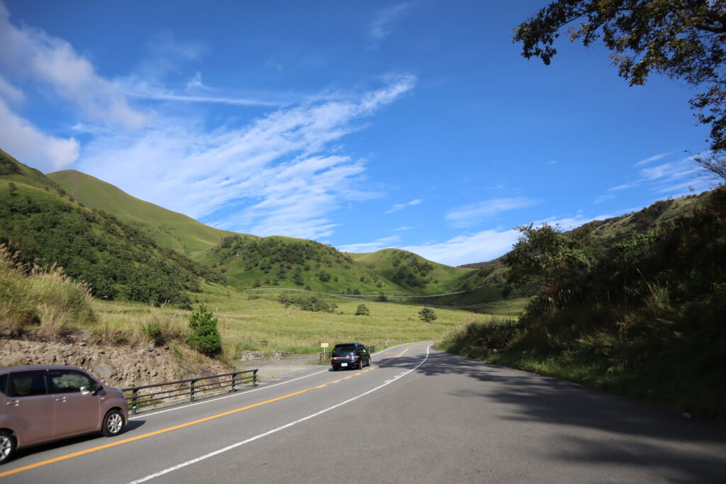
Mt.Aso(Kusasenri)-草千里
Parking MAPCODE:
🔒Book rental car or hotelWhat is MAPCODE?
16:15
If you still have time, head to “Kusasenri” on Mt. Aso.
Panorama Line Road, which was ranked No. 1 in Japan in a motorcycle magazine, will greet you with the sight of vast grasslands.
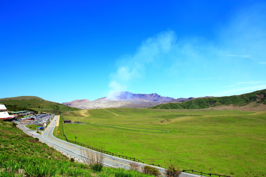
If there are no restrictions on volcanic gases, you can visit the crater. You can take the Aso Park toll road (800 yen) to the parking lot next to the crater.
Please check current restrictions before your visit.
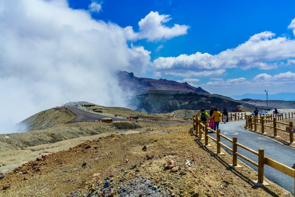
Information on restrictions for the Aso Volcano Center
30min
There are also flower gardens such as “Gandhi Farm” and “Kujyu Flower Park” on this day. If you are traveling during the best time for flowers, give priority to this area.

7
Inn in Aso
The driving map will show additional 10-20 hidden gems and local restaurants for the day!
You can travel freely, choosing only the spots you like!
Check pin color and MAPCODE usage.
Aso town is a small town located inside the vast caldera of Mt.Aso. The inns are spread over a wide area around Mt. Aso.
- Inn Type
There are a variety of inns from 3-star western-style hotels to 5-star Japanese Ryokans. Please book at your preferred type of inn. - Parking
Most inns will offer free parking. - Onsen
Some luxury Ryokans have Onsen. - Meal Plan Reservations
Aso is a rural area and there are few restaurants. Be sure to make a reservation with a plan that includes dinner and breakfast.
Aso – Aso🔒
Start: Aso(阿蘇)
Finish: Aso(阿蘇)
Mileage:130km
Travel Pace: Relaxing
This will be a day trip from Aso as we will be staying in Aso for a couple of nights.
The driving distance will vary depending on the destination, but in the case of the recommended round trip to Takachiho, it will be about 130 km. If you do not go to Takachiho, we recommend a relaxing trip around Mt.Aso.
1
Inn in Aso
Parking MAPCODE:
🔒Book rental car or hotelWhat is MAPCODE?
10:00
Due to the short driving distance, it is okay to depart at a leisurely pace.
However, if you did not visit “Mt.Aso” yesterday, leave early and go there first. Driving up the Aso Panorama Line Road, which was ranked No. 1 in the national driving road rankings, you will be greeted by the sight of vast grasslands and an active volcano!
75min
2
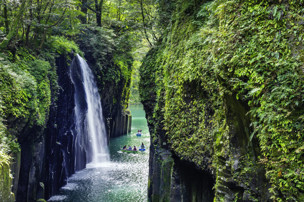
Takachiho Gorge-高千穂峡
Parking MAPCODE:
🔒Book rental car or hotelWhat is MAPCODE?
11:15
First, let’s move on at once to visit “Takachiho Gorge”. It is one of the most beautiful gorges in all of Japan and one of the most recommended spots on this entire road trip.
Boat rentals are very popular and sometimes crowded, but highly recommended!
10min
There are not many restaurants in Takachiho, but please refer to the driving map for recommended soba restaurants and Takachiho beef restaurants.
3
Kunimigaoka Observatory-国見ヶ丘展望台
Parking MAPCODE:
🔒Book rental car or hotelWhat is MAPCODE?
13:15
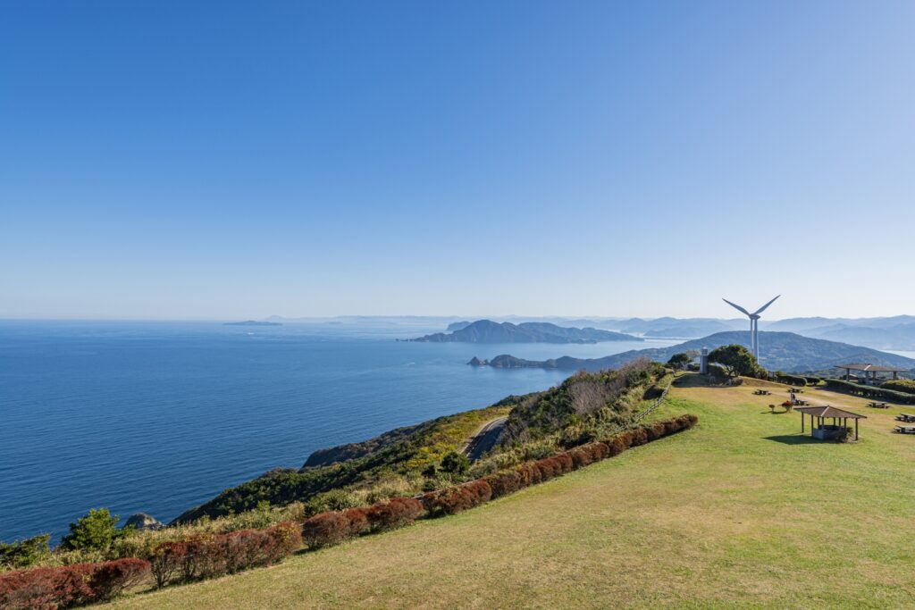
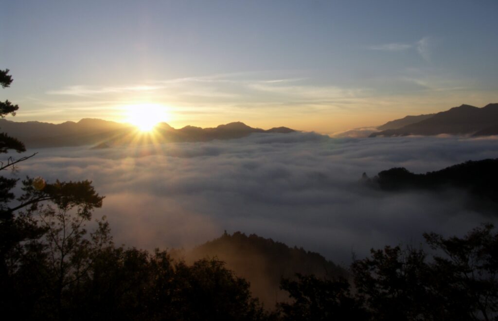
“Kunimigaoka Observatory” near Takachiho Gorge is also worth a visit. It is hard to describe from the picture, but from this 513-meter-high hill, you can see the Takachiho Basin to the east and Mount Aso to the west, and Takachiho, a town said to be the home of the gods, can be seen from all directions. It is famous for the sea of clouds, but it is also a sight to behold at other times of the year.
20min
4
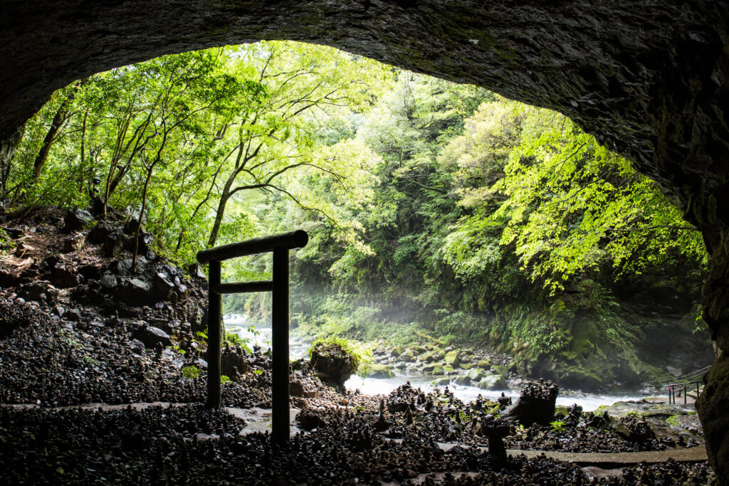
Amanoiwato Shrine-天岩戸神社
Parking MAPCODE:
🔒Book rental car or hotelWhat is MAPCODE?
14:30
10km away from Takachiho Gorge, the “Amanoiwato Shrine” is also recommended. A 10-minute walk along a riverside path called “Amanoyasukawara” will lead you to a fantastic torii gate in a cave.
60min
5
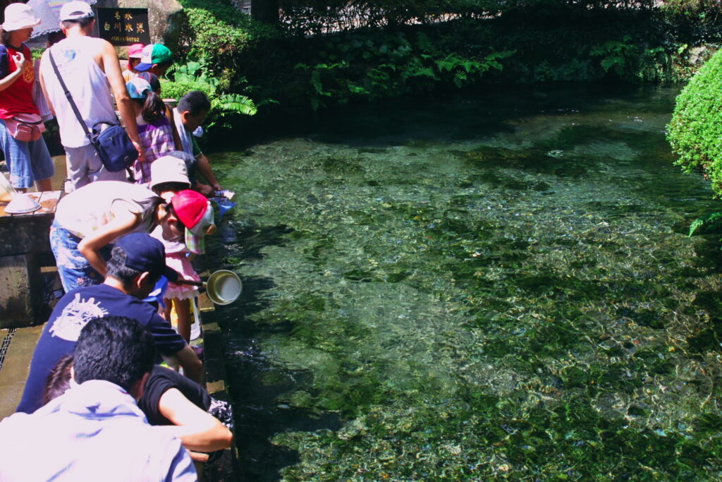
Shirakawa Suigen-白川水源
Parking MAPCODE:
🔒Book rental car or hotelWhat is MAPCODE?
16:30
Back to Aso and if you still have time, stop by “Shirakawa Suigen”. You can draw natural water from the foot of Mt. Aso.
30min
There are some cherry blossom viewing spots along the route on this day. If you visit during the cherry blossom season, please refer to the driving map.
6
Inn in Aso
Parking MAPCODE:
Please head to the hotel you reserved.What is MAPCODE?
Let’s return to the same inn in Aso as the previous day.
The driving map will show additional 10-20 sightseeing spots and local restaurants for the day!
You can travel freely, choosing only the spots you like!
Check pin color and MAPCODE usage.
Aso town is a small town located inside the vast caldera of Mt.Aso. The inns are spread over a wide area around Mt. Aso.
- Inn Type
There are a variety of inns from 3-star western-style hotels to 5-star Japanese Ryokans. Please book at your preferred type of inn. - Parking
Most inns will offer free parking. - Onsen
Some luxury Ryokans have Onsen. - Meal Plan Reservations
Aso is a rural area and there are few restaurants. Be sure to make a reservation with a plan that includes dinner and breakfast.
Aso – Kumamoto🔒
Start:Aso(阿蘇)
Finish:Kumamoto(熊本)
Mileage:70km
Travel Pace: Relaxed
The driving distance on this day is only about 70km, so you can enjoy sightseeing at your leisure.
1
Inn in Aso
Parking MAPCODE:
🔒Book rental car or hotelWhat is MAPCODE?
9:00
On this day you will travel from Aso to Kumamoto. It’s okay to leave late around 10:00am if you have visited Mt. Aso the day before.
15min
2
Mt.Aso(Kusasenri)
Parking MAPCODE:
🔒Book rental car or hotelWhat is MAPCODE?
9:15
The first stop is mt.Aso. You can drive “Panorama Line” road, which was ranked No. 1 in Japan in a motorcycle magazine, will greet you with the sight of vast grasslands. We also recommend visiting the Aso Volcano Museum.
If there are no restrictions on volcanic gases, you can visit the crater. You can take the Aso Park toll road (800 yen) to the parking lot next to the crater.
Please check current restrictions before your visit.
Information on restrictions for the Aso Volcano Center
75min
3
Kumamoto Castle
Parking MAPCODE:
🔒Book rental car or hotelWhat is MAPCODE?
13:00
Then head to Kumamoto Castle. After parking your car in the parking lot of Kumamoto Castle, enjoy lunch at Sakuranobaba Johsaien Castle Town, a shopping street with the theme of the Edo period (1603-1868).
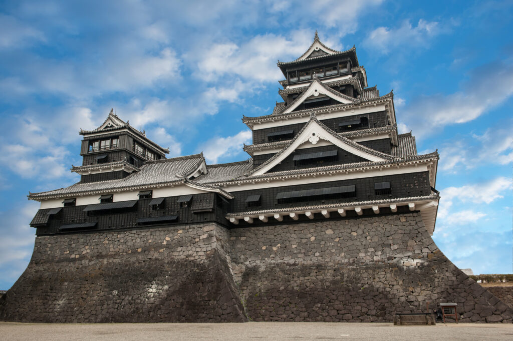
Afterward, you will walk to Kumamoto Castle. Kumamoto Castle is famous for its Uto yagura (turret) and huge Ishigaki (stone walls) that have remained since the Edo period. The 2016 Kumamoto Earthquake destroyed these huge stone walls, and Kumamoto Castle was in danger of collapsing. However, thanks to the desperate efforts of the people, restoration is now progressing, and you can visit the castle with peace of mind.

20min
4
Suizenji Garden
Parking MAPCODE:
🔒Book rental car or hotelWhat is MAPCODE?
15:50

Next, you will head to Suizenji Garden. In the garden where Aso’s subterranean water springs quietly, you can stroll through the elegantly beautiful Japanese garden while looking at the pond, Tsukiyama, pine trees, etc. From the end of March to the beginning of April, cherry blossoms bloom along the promenade, and many people come to see the cherry blossoms.
20min
5
Inn in Kumamoto
Parking MAPCODE:
Please head to the hotel you bookedWhat is MAPCODE?
17:15
Please spend a relaxing night in Kumamoto.
If time permits, Kikuchi Gorge is also recommended. The water flowing through this valley creates waterfalls of various sizes, and the varied scenery is spectacular. Especially in autumn, the colored leaves that shine in the stream (late October to late November) are wonderful, and in spring you can enjoy the fresh greenery.

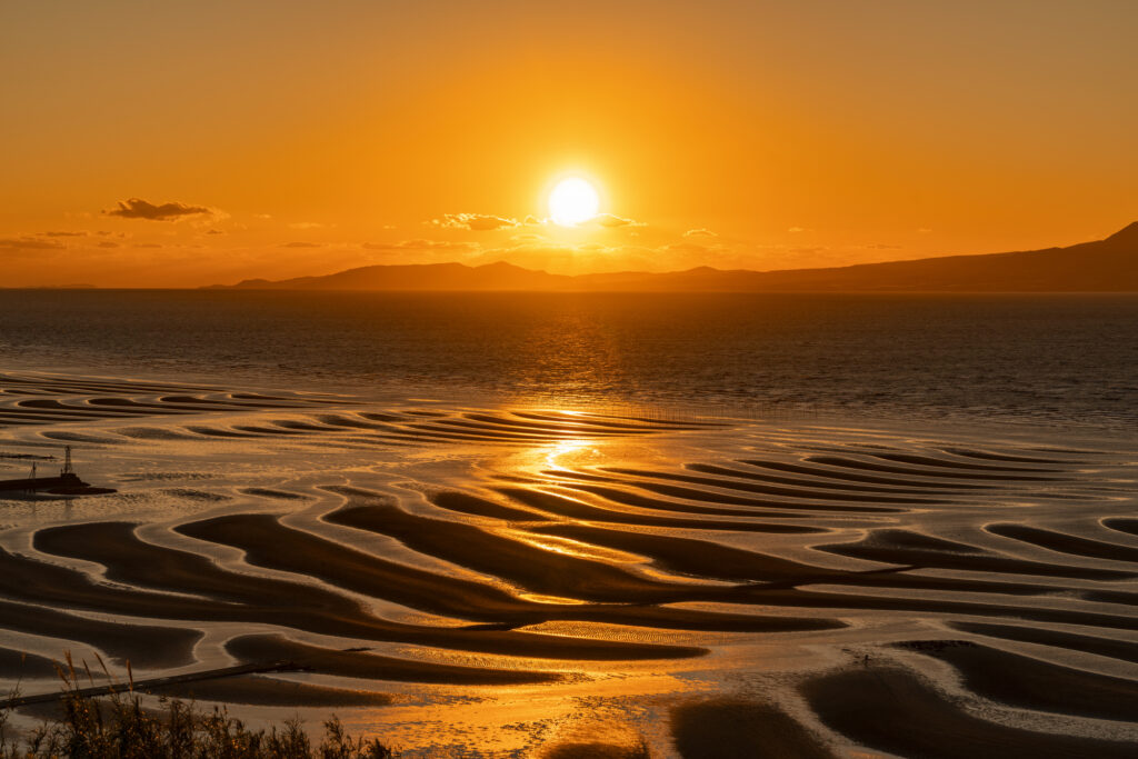
The Okoshiki Coast Observatory is also recommended. The tidal range is extreme here, and the crescent-shaped pattern created by the wind and waves is a spectacular sight. The setting sun is also wonderful here, and you can enjoy the combination of the beautiful beach and the setting sun. It is said that sunset and low tide often overlap from January to April.
You can check parking MAPCODE in Driving Map.
The driving map will show additional 10-20 spots for the day! You will travel only to your favorite spots.
Check pin color and MAPCODE usage.
Kumamoto is the 3rd biggest city in Kyushu. The inns are concentrated south on the southeast side of Kumamoto Castle. It is better not to stay around Kumamoto Station due to a few restaurants for dinner.
- Inn Type
Most of these inns are 3 to 4-star western-style hotels. - Parking
Some inns have official parking but in addition to the accommodation fee, the parking lot fee will be charged separately. - Onsen
There is no onsen in this town and no inns have onsens. - Meal Plan Reservations
As many restaurants are open till midnight, it is recommended to book your inns with breakfast only or without meals.
Kumamoto – Fukuoka🔒
Start: Kumamoto(熊本)
Finish: Fukuoka(福岡)
Mileage:150km
Travel Pace: Normal
On this day, we will return to Fukuoka from Kumamoto.
The driving distance is about 150 km. The second half of the trip will be on the expressway for about 50 km.
1
Inn in Kumamoto
Parking MAPCODE:
🔒Book rental car or hotelWhat is MAPCODE?
9:00
If you are not staying in Fukuoka today and will be taking the Shinkansen or airplane, please arrange your schedule so that you can return the rental car to the rental store at least one and a half hours before your flight.
10min
2
Kumamoto Castle-熊本城
Parking MAPCODE:
🔒Book rental car or hotelWhat is MAPCODE?
9:10
First, we will head to Kumamoto Castle, the symbol of Kumamoto, which was damaged by the Kumamoto Earthquake in 2016, but restoration work on the castle tower was completed in March 2021.
20min
3
Suizenji Jojuen Garden-水前寺成趣園
Parking MAPCODE:
🔒Book rental car or hotelWhat is MAPCODE?
11:30
Suizenji Jojuen Garden is a Japanese garden with a pond garden style. It is only 4 km away from Kumamoto Castle, so it is recommended to visit there as well.
70min
4
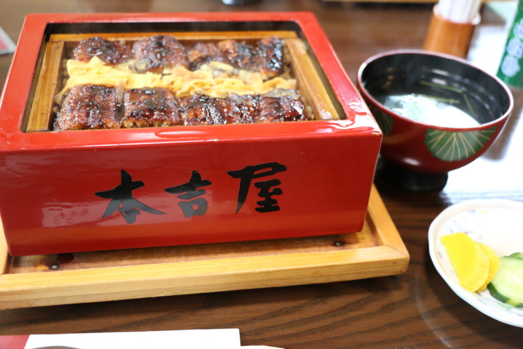
Ganso Motoyoshiya-元祖本吉屋
Parking MAPCODE:
🔒Book rental car or hotelWhat is MAPCODE?
13:20
Yanagawa is famous for its eels. Among them, Motoyoshiya has been in business for 300 years and serves the best eels. There is also a cheap and tasty udon restaurant nearby, which is also recommended.
5min
5
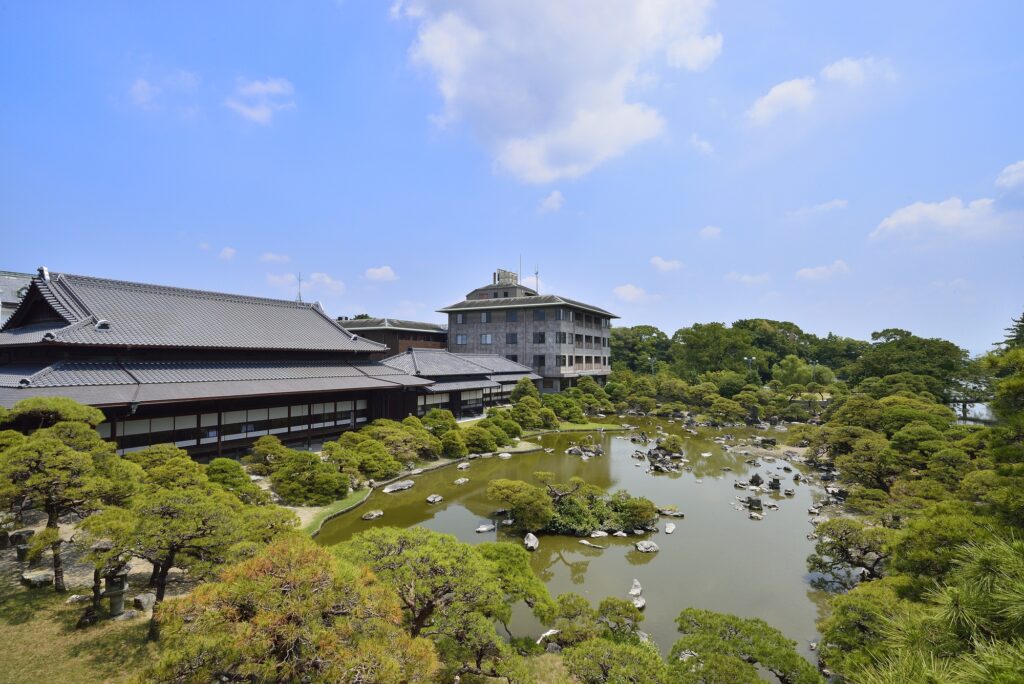
Ohana Shotoen-御花・松涛園
Parking MAPCODE:
🔒Book rental car or hotelWhat is MAPCODE?
14:30
Ohana Shotoen is a former domain lord’s residence and a splendid garden that has been selected as a national place of scenic beauty.
60min
6
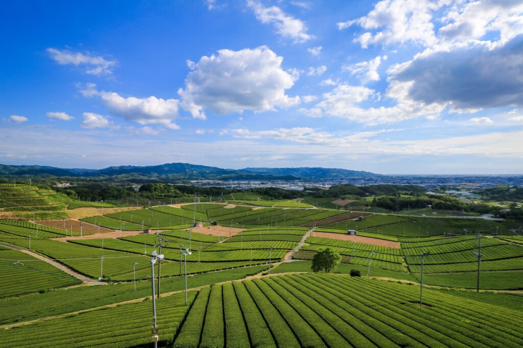
Yame Chuo Tea garden-ハ女中央大茶園 展望所
Parking MAPCODE:
🔒Book rental car or hotelWhat is MAPCODE?
16:30
The last highlight of the day was the Yame Chuo Tea garden. This area is the production area of “Yame-cha”, one of the finest teas in Japan. This is an observatory from which you can look out over the vast tea fields as far as the eye can see. This is a spot that cannot be reached by public transportation or even by bus tours, but only by a road trip.
From here, let’s take the expressway (E3) to Fukuoka. It is about 50 km, or 1 hour and 10 minutes.
70min
7
Rental car branch at Fukuoka airport or Hakata Station
Parking MAPCODE:
Please refer driving mapWhat is MAPCODE?
18:00
This concludes your Kyushu road trip.
When you return to Fukuoka, refuel and then return the car to the car rental branch. Use the MAPCODE on the driving map for the nearest gas stations at Hakata Station and Fukuoka Airport.
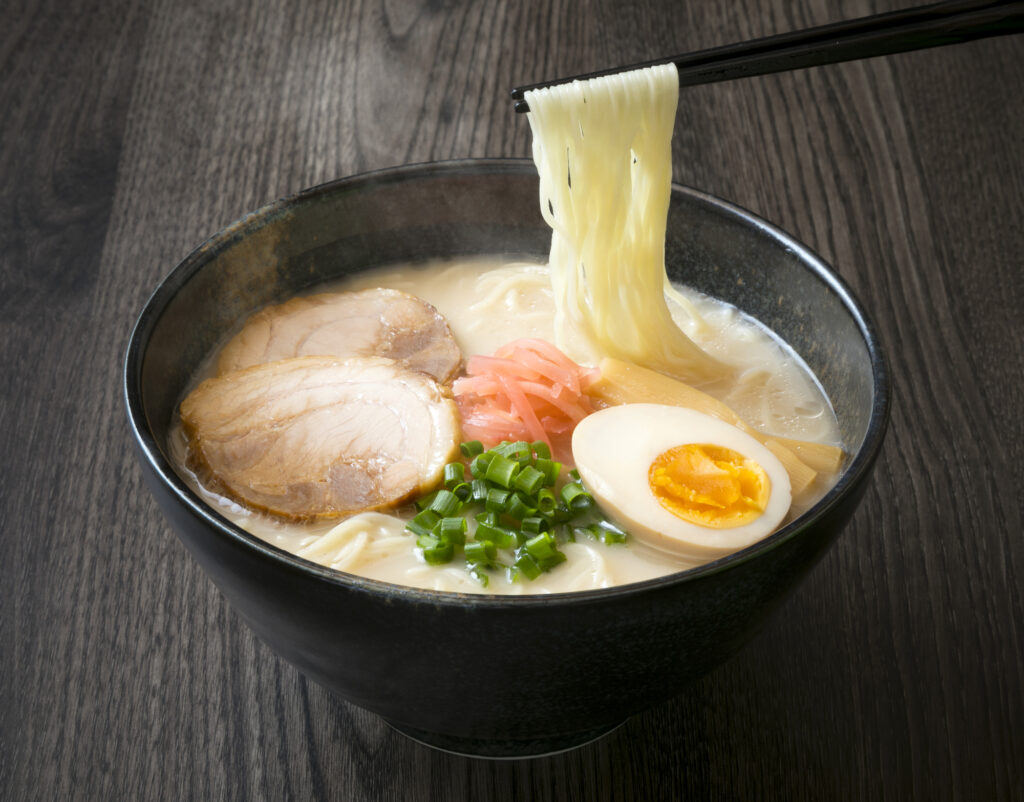
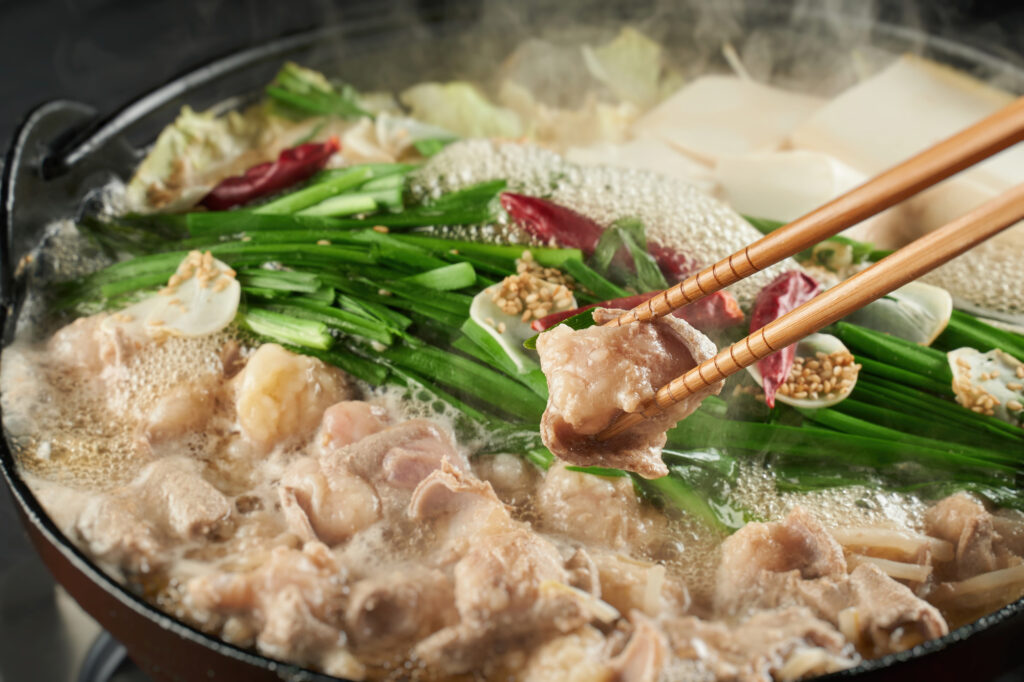
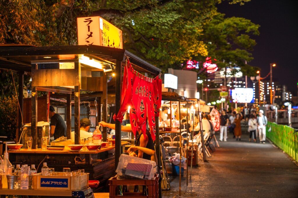
Fukuoka offers a wide variety of culinary delights. For dinner, try Hakata ramen, Motsu nabe (Motsu hot pot), and other local Fukuoka foods, or even try one of the famous Yatai stalls.
The driving map will show additional 10-20 sightseeing spots and local restaurants for the day!
You can travel freely, choosing only the spots you like!
Check pin color and MAPCODE usage.
Fukuoka is the biggest city in Kyushu and the gateway of Kyushu Travel. It takes 15 min to Fukuoka Airport by subway. There are hundreds of accommodations around “Hakata Station”, Nakasu downtown area, and “Tenjin Station”.
- Inn Type
Most of these inns are 2 to 5-star western-style hotels. - Parking
Some inns have official parking but in addition to the accommodation fee, the parking lot fee will be charged separately. - Onsen
There is no Onsen in this town and no inns have Onsens. - Meal Plan Reservations
As many restaurants are open till midnight, it is recommended to book your inns with breakfast only or without meals.
Unlock MAPCODE & Maps
We provide “Travel Kit” to make your journey much more attractive.
- Get “Hidden Gems” info along this itinerary
- Maximize travel time by parking MAPCODE for all spots
- Discover local delicacies with Restaurants List
Hotel&Car Booking
- Highly recommended to book a rental car first to book hotels with special discounts.
- Book hotels. Recommend hotels have parking and convenient locations for dining and strolling. Selected hotels can be booked with a single payment.
With rental car booking number, you can book hotels with exclusive discounts(Avg.18%, Max45% OFF)!
Rental Car Booking
Please rent a car with below “Rentalcars.com” link.
- The abundant number of rental cars
- Price comparisons with several major car rental companies
- Free cancellation

Pick-up & Drop-off Location Guide
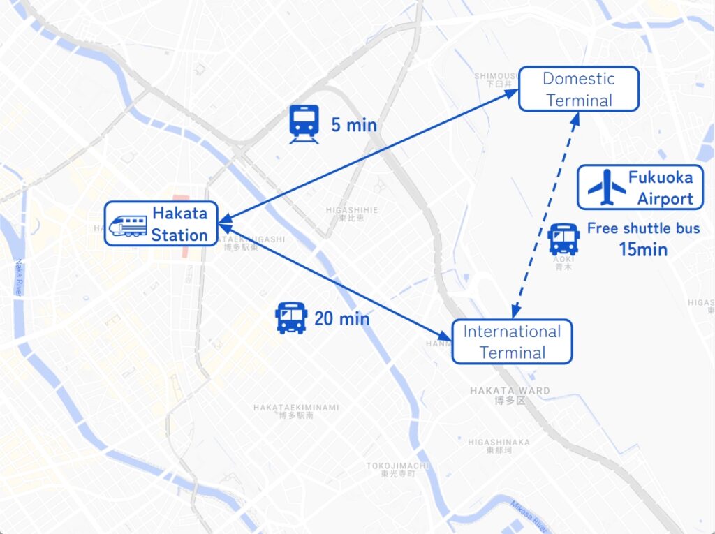
- Fukuoka Airport
The main international airport in Kyushu. Recommended for Pick-up.
If you arrive after 14:00, consider staying overnight in Fukuoka City and departing the next morning.
It takes 5-20min to Hakata station by metro or bus. - Fukuoka City
The biggest and gateway city in Kyushu. Most car rental shops are located around Hakata Station.
Important reminder for renting a car
- GPS(Car Navigation System)
MAPCODE from Drive Japan navigates you precisely to the parking lot. GPS from major car rental companies(Nippon, ORIX, Nissan, Times) are always MAPCODE compatible. However, if you are renting a car from another company, we recommend that you check with the rental company after making a reservation, just to be sure. - One-way Rental
You can rent at Fukuoka Airport and return to Fukuoka city, and vice versa. Normally, the one-way charge is free of charge. - Child Seat
In Japan, the use of a child safety seat or baby seat is mandatory for children under 5 years old.
Be sure to request one from “Extras”. - Snow Tire
Kyushu rarely gets much snow, even in winter. However, if you drive around Aso from December to February, recommend requesting it.